

War and Ukraine's Natural Landscapes: The Scale of Impact and Research
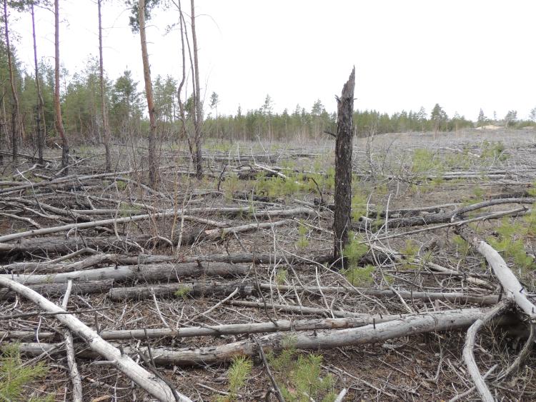
Russia's war is inflicting systemic damage to Ukraine's natural landscapes: between 2022 and 2026 alone, more than 3.6 million ha of these landscapes were affected by fires, with 2025 being a record year (1.4 million ha), while 73–85% of the total area affected by fires is located within the 60 km buffer zone along the front line. Although fires in open landscapes account for the majority of the affected area (91%), forest areas remain the most vulnerable to long-term carbon and biodiversity losses. Fire monitoring data, scientific research, reports by international organisations, estimates of CO₂-eq. emissions, data from the SE “Forests of Ukraine,” and information from state authorities on the scale of restricted access to forests and natural landscapes due to the risk of landmines demonstrate the significant scale of damage to natural landscapes. These data underscore the urgent need to study the impacts of the war on Ukraine’s natural landscapes.
Russia's full-scale invasion of Ukraine, which began on 24 February 2022, has fundamentally changed the fire regime across the country’s natural landscapes. This is shown by the results of detailed fire monitoring in Ukraine and of the analysis of fire dynamics for 2022–2026, which are based on remote sensing methods, image analysis and the delineation of fire perimeters. The method combines daily thermal anomaly products from MODIS (1 km) and VIIRS (375 m) with Sentinel-2 L2A time series at 20 m spatial resolution, which are used for manual delineation of burn perimeters. Over four and a half years of active hostilities, the total burned area reached 3.61 million ha, with the highest annual figure recorded in 2025 – 1.40 million ha. Among all types of natural landscapes, forest fires accounted for 282, 000 ha. Across all land-cover classes, in individual years 73–85% of the total burned area was located within the 60 km buffer zone along the frontline. The fire perimeter database enables the analysis of fire dynamics by season, land-cover type and spatial distribution.
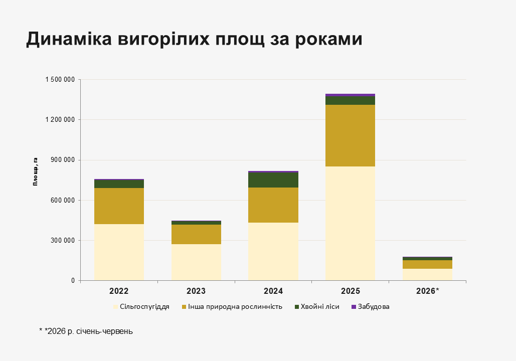
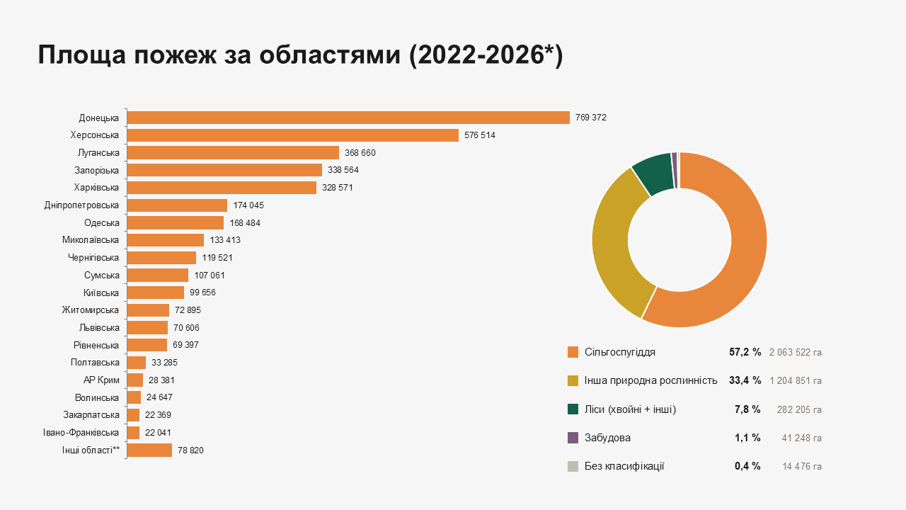
In the structure of the burned area, cropland dominates with 2.0 million ha (57.2%), followed by other natural vegetation with 1.2 million ha (33.4%), while forests account for 282.2 thousand ha (7.8%), of which 147.3 thousand ha are coniferous forests. The annual dynamics show a pronounced peak in 2025, which in total amounts to 1.4 million ha of burned area (39% of the entire burned area). The most fire-hazardous months of the year are March and July–September. In regional terms, 64% of the total burned area is concentrated in five frontline oblasts: Donetsk (769,372 ha), Kherson (576,514 ha), Luhansk (368,660 ha), Zaporizhzhia (338,564 ha) and Kharkiv (328,571 ha). In terms of burned forest area, Luhansk (57,819 ha) and Kharkiv (41,645 ha) oblasts rank first. The war is a determining factor, as evidenced by the spatial distribution of fires: 75.4% of all fires occurred within the 60 km buffer zone along the frontline. In temporarily occupied territories, where firefighting is effectively impossible, fires affected 1.5 million ha (42.4% of the total area). Within Emerald Network sites, fires affected a total of 638.900 ha (17.7%), which indicates substantial disturbance of the nature conservation fund.
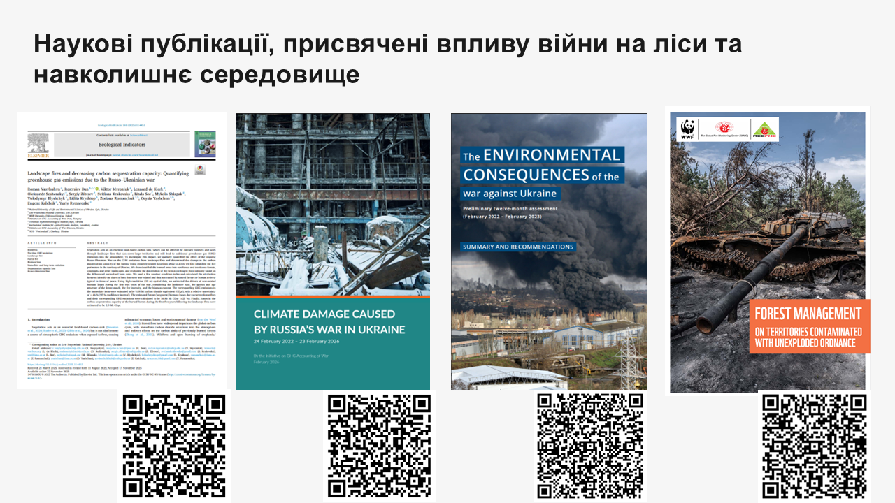
Numerous scientific studies and initiatives of various organisations are aimed at investigating the impact of the war on Ukraine's natural landscapes, with the work of the scientific community of the NUBiP of Ukraine and its international partners playing a prominent role. The basis for systematic monitoring was laid at the very beginning of the full-scale invasion, from the field validation of fire severity indices in Luhansk oblast (Soshenskyi et al., 2022) to the mapping of fires in the forest landscapes of eastern Ukraine for the needs of post-fire forest management (Myroniuk et al., 2022). Drone-based monitoring of pine forests near Izium showed that, following fires, forests recover predominantly through non-native ruderal species, while natural tree regeneration remains weak (Matsala et al., 2026). Research by Myroniuk et al. provides results of a nationwide remote sensing forest inventory in the war-affected area, according to which up to 1.7 million ha of forests are potentially affected (Myroniuk et al., 2024). Other studies by the same research group address the increasing risk of wildfires and the need for ecologically sound silviculture (Matsala et al., 2024), assess threats to protective forest belts in eastern Ukraine (Matsala et al., 2025), and review the effects of land use, climate, and war on fires in the Siverskyi Donets River basin (Milakovsky et al., 2025). The most developed strand is the assessment of greenhouse gas emissions from war-related fires, from carbon emission accounting for 2022 (Zibtsev et al., 2024) to the spatial assessment of emissions and of the lost carbon sink capacity of forests for the whole period of the war (Vasylyshyn et al., 2025), the results of which have fed into the annual reports of the Initiative on GHG Accounting of War (De Klerk et al., 2026) and into the report of the Joint Research Centre of the European Commission on the large fires of 2022 in Europe (Zibtsev et al., 2024). An applied strand is developing in parallel: the rationale for forest management on territories contaminated with unexploded ordnance has been elaborated (Zibtsev et al., 2023), a Plan for integrated landscape fire management in Luhansk oblast has been developed (Zibtsev et al., 2023), as has a methodology for mapping wildland–urban interfaces (WUI) in order to reduce the risks for settlements (Soshenskyi et al., 2024). Increasing attention is being paid to post-war recovery scenarios, from the analysis of pathways for the restoration of forest social-ecological systems (Melnykovych et al., 2025) to the assessment of the introduction of close-to-nature silviculture as an instrument for strengthening forest resilience (Soshenskyi et al., 2025).
Restricted access to natural landscapes
A substantial part of the affected territories remains inaccessible for forest survey and management because of the mine hazard and temporary occupation, which turns contamination with unexploded ordnance (UXO) into a driver of altered fire regimes in its own right: on UXO-contaminated land, not only harvesting and reforestation become impossible, but also patrolling, the construction of firebreaks and ground-based suppression, so that even surface fires develop unimpeded into large-scale events (Zibtsev et al., 2022). According to the State Emergency Service of Ukraine, as of 1 July 2026 some 133.3 thousand km² of the country's territory remains potentially hazardous, while since the beginning of the full-scale invasion the service's explosive ordnance disposal units have surveyed (cleared) 2 thousand km², that is about 1.5% of the contaminated area (State Emergency Service of Ukraine). According to the estimates of SE “Forests of Ukraine”, 984.1 thousand ha of forest land have been affected as a result of the armed aggression, of which 452.3 thousand ha are contaminated with UXO, and of these only 46.2 thousand ha had been cleared as of July 2026. The mine hazard thus produces the effect of a “second exclusion zone”, in which part of the forest fund effectively drops out of the system of forest management and fire protection for an indefinite period, while the resumption of forest management activities on these areas is postponed by at least decades.
The management of territories affected by hostilities, occupation and contamination with unexploded ordnance requires several main lines of action, which are interrelated:
-
The first and most urgently needed is a strategy for managing natural landscapes damaged by the war and contaminated with unexploded ordnance, with a focus on forests. It should define the priority areas for survey, demining and restoration, the management regimes for areas whose access will remain restricted for decades, and the mechanisms of inter-agency cooperation between the forest sector, mine action operators and the State Emergency Service.
-
The second element should be a concept for a forest fire management system to reduce the risk of large-scale fires under the conditions of climate change and war. This implies a shift from the traditional orientation towards suppressing all fires without exception to integrated management with a stronger preventive component, remote monitoring and fuel management on territories inaccessible to ground-based response.
-
The third element should be practical recommendations on silvicultural measures for reducing the vulnerability of forest landscapes to fires, above all in pine forests, where the combination of monoculture stands, high fire hazard and UXO contamination creates the most risk-prone conditions.
The experience of Germany and Croatia
In Germany, according to OSCE estimates, about 250 thousand ha of active and former military training sites are contaminated with unexploded ordnance, with a further 300 thousand ha affected by munitions from the Second World War (OSCE, GFMC, 2014). The reality of this threat is confirmed by large forest fires on such terrain, in particular the 2019 fire near Lübtheen in Mecklenburg-Vorpommern (The Local, 2019) and the 2023 fire near Jüterbog outside Berlin, when firefighters had to advance behind armoured vehicles in order to approach the fire safely (CTIF, 2023). In response to this challenge, the team of the Global Fire Monitoring Center (GFMC, Freiburg) under the leadership of J. G. Goldammer developed, in the Heidehof-Golmberg nature reserve (Brandenburg), a prescribed burning technology for the maintenance of Calluna heathlands on munition-contaminated terrain, using converted armoured military vehicles as a means of safe ignition and suppression (Goldammer et al., 2012; Goldammer et al., 2016). The Croatian experience offers a long-term example of the post-war demining of landscapes: after the 1991–1995 war, forests and wooded land constitute the overwhelming majority of all mine-suspected areas of the country (Lider Media, 2017), and the demining of forests within protected areas is carried out with the support of EU funds through the Naturavita and Fearless Velebit projects (OBCT, 2023). The large fire of 2017 in the area of the Velebit Nature Park and the Paklenica National Park could not be suppressed by ground forces precisely because of the unconfirmed mine status of the territory, which corresponds closely to the present-day challenges facing Ukrainian foresters and rescuers.
It can be stated that Ukraine is now facing a problem for which it has no ready institutional answers: war-damaged landscapes require not restoration in the pre-war sense, but the elaboration of a fundamentally new management regime, one that treats the long-term inaccessibility of the territory as a lasting condition rather than as a temporary obstacle. The experience of other countries shows that delay in developing such a model is costly: the later the strategy is formed, the higher the probability of repeated fires, of stand degradation and of the spread of invasive species on areas that there was no one and nothing to tend. The scientific underpinning of this process, from monitoring to practical recommendations, should therefore be regarded not as an accompanying activity, but as a component of national security and a precondition for post-war environmental recovery.
Despite the ongoing hostilities, research on the condition of natural landscapes and the preparation of solutions for their restoration do not stop, to a large extent thanks to the support of international donors. The [Deutsche Bundesstiftung Umwelt](https://www.dbu.de/) (DBU), one of the largest environmental foundations in Europe, has consistently supported Ukrainian researchers in the field of environmental and nature protection since the beginning of the full-scale invasion. Scientific and practical work is also supported by [WWF-Ukraine](https://wwf.ua/), the Swiss [Velux Stiftung together with BFH-HAFL](https://www.bfh.ch/en/research/reference-projects/from-crisis-to-resili…), the EU programmes Erasmus+ and Horizon Europe, the Joint Research Centre of the European Commission (JRC), FAO, UNDP and the Global Fire Monitoring Center (GFMC), among others. The consolidation of scientific, donor and institutional efforts is the main precondition for effective and well-founded decisions on the management of natural landscapes affected by the war.