- Головна
- About REEFMC
- Landscape Fire Monitoring and Advisories
- Current Fire Situation
- Regional news
- Regional cooperation
- REEFMC activities
- National networking
- Fire Management on Terrains contaminated by Unexploded Ordnance (UXO)
- Fire management in the Chornobyl Exclusion Zone
- Fire Research
- Fire policy and legislation
- Trainings of firefighters
- Projects
- Publications
- REEFMC Services
- Partners and Sponsors
- Contacts
- Staff
Landscape Fire Monitoring and Advisories
LANDSCAPE FIRE AND SAFETY ADVISORIES DURING THE WAR IN UKRAINE
During the war, the aggression and partial occupation of Ukraine by the Armed Forces of the Russian Federation, fires are occurring as collateral damages and purposely set. REEFMC and GFMC are monitoring the situation. Landscape Fire Bulletins include updates on fires on the territory of Ukraine (in ecosystems, agricultural lands and in cities, including updated maps of active fires, updated fire statistics, maps and details of large fires). Safety Advisories have been issued to address the threats of wildfires burning on terrain contaminated with unexploded ordnance (UXO) and radioactivity. The map shows the up-to date accumulated locations of fires depicted by satellites.


In order to accurately assess fire damage, all areas affected by fires were mapped. Daily front line (30+30 km) coordinates were provided by ZOI Network to define fires that occurred in the zone of direct impact (ZDI). Distribution of burned land cover types within fire perimeters were mapped using the Copernicus Dynamic Land Cover map at 100 m resolution for 2019 (Copernicus Global Land Operations "Vegetation and Energy"). The image mosaics were created using the Copernicus Sentinel 2 L2A data (Copernicus, 2021), cleaned of clouds and cloud shadows, and then combined into median mosaics at a 20 m spatial resolution. Detailed information about the product - https://land.copernicus.eu/en/map-viewer. Image mosaics were also used to map fire severity. Using the fire severity maps, we associated each land cover class (coniferous forest, deciduous forest, other natural landscapes, agricultural land, and settlements) within the fire perimeters with the dominant fire severity level (i.e., low, medium, and high). This information allowed us to assign different carbon emission factors to distinct fires and land cover types. In this way, we collected data for over 17 thousand fire polygons/perimeters within Ukraine.
The network of nature conservation areas of European importance, which was created to implement the provisions of the Berne Convention on the Protection of Wild Flora and Fauna and Natural Habitats in Europe (Emerald Network) (http://emerald.net.ua/), was used for the analysis of areas of nature conservation value that were affected by fires. The analysis was performed using a free geographic information system. QGIS (3.2.1), which is one of the most functional and convenient desktop geographic information systems.
Landscape Fires 2024 (Landscape Fires Map_2024)
- 12_December_Landscape Fire Bulletin (Map_December)
- 11_November_Landscape Fire Bulletin (Map_November)
- 10_October_Landscape Fire Bulletin (Map_October)
- 09_September_Landscape Fire Bulletin (Map_September)
- 08_August_Landscape Fire Bulletin (Map_August)
- 07_July_Landscape Fire Bulletin (Map_July)
- 06_June_Landscape Fire Bulletin (Map_June)
- 05_May_Landscape Fire Bulletin (Map_May)
- 04_April_Landscape Fire Bulletin (Map_April)
- 03_March_Landscape Fire Bulletin (Map_March)
- 02_February_Landscape Fire Bulletin (Map_February)
- 01_January_Landscape Fire Bulletin (No fires)
Landscape Fires 2023 (Landscape Fires Map_2023)
- January_Landscape Fire Bulletin (Map_January)
- February_Landscape Fire Bulletin (Map_February)
- March_Landscape Fire Bulletin (Map_March)
- April_Landscape Fire Bulletin (Map_April)
- May_Landscape Fire Bulletin (Map_May)
- June_Landscape Fire Bulletin (Map_June)
- July_Landscape Fire Bulletin (Map_July)
- August_Landscape Fire Bulletin (Map_August)
- September_Landscape Fire Bulletin (Map_September)
- October_Landscape Fire Bulletin (Map_October)
- November_Landscape Fire Bulletin (Map_November)
Landscape Fires 2022 (Landscape Fires Map_2022)
In order to accurately assess the fire damage, all areas affected by fire in 2022 were mapped. The study used the following data sources: spatial and temporal information on fires according to the OroraTech product (used to find the coordinates of fires); time series of Sentinel 2 satellite images (level 2A), which were used to map the perimeters of fires based on the locations of fires and dates of fires; Copernicus land cover with a resolution of 100 m for 2019; information on the line of hostilities and the temporarily occupied territory was taken from the open resource of the Institute for the Study of War (in dynamics).
Distribution of fires by landscape type within months of the year 2022
Spatial distribution of fires (maps)
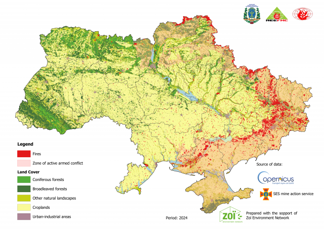
Map of active fires on the territory of Ukraine for the 2024
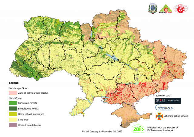
Map of active fires on the territory of Ukraine for the 2023

Map of active fires on the territory of Ukraine for the 2022
Safety Advisories
- REEFMC-GFMC advisory on wildfire safety on UXO-contaminated terrain in Ukraine (Ukrainian; 22 March 2022) (PDF, 0.4 MB)
- REEFMC-GFMC advisory on wildfire safety on UXO-contaminated terrain in Ukraine (English; 22 March 2022) (PDF, 0.4 MB)
- Advisory on wildfires in Chernobyl Exclusion Zone (ChEZ) burning on radioactively contaminated terrain (in Ukrainian; 21 March 2022) (PDF, 0.6 MB)
- Advisory on wildfires in Chernobyl Exclusion Zone (ChEZ) burning on radioactively contaminated terrain (in Ukrainian; 25 March 2022) (PDF, 0.4 MB)

Total fires depicted by satellite sensors in Kyiv Oblast, 01-15 March 2022. Source: REEFMC

The bombardments and rocket attacks by Russian Armed Forces are causing fires in residential areas / cities and surrounding landscapes. Satellite-derived locations of fires in the map show the situation on 15 March 2022 NW Kiev and Irpin. Source: Orora

Facebook SITREP of the General Staff of Armed Forces, Ministry for Defense, Ukraine, 23 March 2022, reporting about land mining by Russian Forces

Radioactive emissions from wildfires burning in Chernobyl Exclusion Zone (ChEZ) on 11 March 2022, transport towards Ukrainian territories. Source: https://nubip.edu.ua/node/106588

Radioactive emissions from wildfires burning in Chernobyl Exclusion Zone (ChEZ) on 16 March 2022, transport towards Belarus. Source: https://nubip.edu.ua/node/106588
Background Information
In 2013 the Global Fire Monitoring Center (GFMC) published a comprehensive White Paper directed to the United Nations and International Organizations entitled Vegetation Fires and Global Change Challenges for Concerted International Action. This White Paper includes an analysis of dangerous wildfires affecting human security in the landscapes of Eurasia, including threats of fires burning on lands contaminated by radioactivity, UXO and land mines:
- UN White Paper: Chapter 22 – Wildfires and Human Security in Cultural Landscapes in Transition Examples from Temperate-Boreal Eurasia (by J.G. Goldammer) (PDF, 0.2 MB)
- White Paper directed to the United Nations and International Organizations Vegetation Fires and Global Change Challenges for Concerted International Action (PDF, 3.7 MB)

Ground and aerial impressions of UXO-contaminated territories in Germany: Advanced armoured and UAV technologies for safe prescribed burning and wildfire control.Source: GFMC (Goldammer et al. [2012]; see reference further down)
Safe Fire Management on Contaminated Terrain
In 2014 the Organization for Security and Cooperation in Europe (OSCE) commissioned the Report ”Best practices and recommendations for wildfire suppression in contaminated areas, with focus on radioactive terrain” (Goldammer, J.G., Kashparov, V., Zibtsev, S., Robinson, S., Freiburg-Basel-Kyiv, 53. p.)
- English Version (PDF, 3.1 MB)
- Russian Version (PDF, 3.8 MB)
- BCMS Version (PDF, 4.5 MB)
- Version for use in FYR of Macedonia (PDF, 4.6 MB)
- Albanian Version (PDF, 4.4 MB)
In 2018 the Regional Eastern Europe Fire Monitoring Center (REEFMC) published the pocket guidelines for fire management in the Chornobyl Exclusion Zone, a result of cooperative efforts between REEFMC, the Chornobyl Fire Management Agency and the U.S. Forest Service:
- Pocket Guidelines for Fire Management in the Chornobyl Exclusion Zone (in Ukrainian) (PDF, 13.0 MB)
International Consultation on Fire in Irradiated Forests
An International Meeting on Reduction of Disaster Risk from Catastrophic Wildfires in the Chernobyl Irradiated Forests was held under the auspices of the National Agricultural University of Ukraine, Yale University, GFMC / UNISDR in Kiev, Ukraine, 25-28 July 2007.
Ukraine: Second National Round Table and Consultation on Irradiated Forests
The Ministry of Ukraine on Emergencies and Affairs of Populations Affected by the consequences of the Chernobyl catastrophe convened a Round Table on Reduction of Risk of Disaster from Wildfires in the Chernobyl Irradiated Forests. The meeting was held on 6 October 2008 at the Ministry and cosponsored by Yale University School of Forestry and Environmental Studies, Global Institute of Sustainable Forestry (U.S.A.) and the Global Fire Monitoring Center (GFMC).
Meeting report (PDF, 17 KB)
Advanced Seminar Wildfires and Human Security: Fire Management on Terrain Contaminated by Radioactivity, Unexploded Ordnance (UXO) and Land Mines
This seminar addressed the consequences of wildfires and fire management on contaminated terrain and was conducted in Kiev and Chornobyl, Ukraine, 6-8 October 2009, by the Global Fire Monitoring Center (GFMC) in the frame of the activities of the Council of Europe (CoE) and the joint project Enhancing National Capacity on Fire Management and Risk Reduction in the South Caucasus (Environment and Security Initiative [ENVSEC]), the UNISDR Regional Southeast Europe / Caucasus and Central Asia Wildland Fire Networks and the UNECE / FAO Team of Specialists on Forest Fire.
- Background information (English) (PDF)
- Background information (Russian) (PDF)
- Seminar brochure (PDF, 3.3 MB)
- Letter of Endorsement by the Speaker of the Ukrainian Parliament Mr. Litvin
- Seminar report (PDF, 0.1 MB)
- Chernobyl Resolution on Wildfires and Human Security: Challenges and Priorities for Action to address Problems of Wildfires burning on Terrain Contaminated by Radioactivity, Unexploded Ordnance (UXO) and Land Mines (PDF, 52 KB)
International Conference ”Twenty-five Years after the Chornobyl Accident”
The International Conference ”Twenty-five Years after Chornobyl Accident. Safety for the Future” was held in Kyiv / Chornobyl, Ukraine, 20-21 April 2011. A joint presentation ”Needs for Development of Wildfire Management in the Chornobyl Exclusion Zone” was given by C.D. Oliver, S.V. Zibtsev, A.M. Hohl, J.G. Goldammer, J. McCarter, M.M. Petrenko and O.A. Borsuk.
- Final agenda of 25 years Chornobyl Accident Conference (with wildfire contributions) (PDF, 1.8 MB)
- Abstract of presentation Needs for Development of Wildfire Management in the Chornobyl Exclusion Zone (PDF, 3.1 MB)
- Forest fires around Chernobyl could release radiation, scientists warn (The Guardian, 26 April 2010)
Opening addresses of the Chornobyl Conference were given by UN Secretary General Ban Ki-Moon and Prime Minister of Urkaine, Mykola Azarov (top and middle), and the Head of the International Atomic Energy Agency (IAEA), Yukiya Amano (bottom)
Regional Consultation Meeting “Environment and Security”
Regional Consultation Meeting: Initiative “Environment and Security”: Perspectives of Environmental Cooperation in Eastern Europe, with the participation of the Regional Eastern European Fire Monitoring Center (REEFMC), with inputs on fire management needs in contaminated forests; Minsk, Belarus (8 September 2014).
- CIS Agreement on Transborder Cooperation in Fire Management (2013) (PDF, 0.1 MB)
- ENVSEC Eastern European Meeting 2014 Agenda (PDF, 0.2. MB)
- ENVSEC Eastern European Meeting 2014 Outcome Statement (PDF, 0.2. MB)
Letter of the Global Fire Monitoring Center (GFMC) directed to the Government of Ukraine
On 11 February 2016 the GFMC sent a letter to Prime Minister Yatsenyuk and suggested the further development of fire management capacities in the Chernobyl Exclusion Zone (ChEZ) (establishment of an innovative system of early detection of fires in the ChEZ and continuation of cooperation in developing fire management capacities in Ukraine between GFMC and Ukrainian partners) (11 February 2016)
- GFMC Letter to Prime Minister Yatsenyuk (PDF, 2.0 MB)
Conserving, Enhancing and Managing Carbon Stocks and Biodiversity in the Chernobyl Exclusion Zone
Inception Workshop of the UNEP-GEF Project “Conserving, Enhancing and Managing Carbon Stocks and Biodiversity in the Chernobyl Exclusion Zone” with the fire management component ; Ministry of Ecology and Natural Resources of Ukraine (MENR) and State Agency of Ukraine on the Exclusion Zone Management, Kyiv, Ukraine (18 April 2016)
- GEF Project Summary (PDF, 0.2 MB)
- GEF-UNEP Chernobyl Project Launch Workshop Agenda (Ukrainian, PDF, 1.1 MB)
- GEF-UNEP Chernobyl Project Launch Workshop Agenda (English, PDF, 0.8 MB)
Kick-off of the OSCE Project on collaborative efforts in fire management in the Chernobyl Exclusion Zone between Ukraine and Belarus
Consultation on the project “Improving radiological and environmental awareness in territories affected by the Chernobyl accident in Belarus and Ukraine with a focus on wildfire management” (2016-2018); OSCE Office Ukraine, Kyiv, Ukraine (18 April 2016)
- Final project fiche (extract) (PDF, 0.3 MB)
First Coordination Meeting on Enhancing Fire Management Capacity in the Chernobyl Exclusion Zone
First National Coordination Meeting on Enhancing Fire Management Capacity in the Chernobyl Exclusion Zone, a cooperative meeting organized by the Regional Eastern European Fire Monitoring Center (REEFMC), the U.S. Forest Service and the GFMC, with GFMC contribution on the International Wildfire Preparedness Mechanism (IWPM) and the EuroFire Competency Standards; preparation of the National Round Table on Fire Management, Ukraine, and the Regional Consultation on Cross-boundary Cooperation in Fire Management (to be held in Kyiv in 2017) under sponsorship of the Council of Europe (CoE), Secretariat of the Euro-Mediterranean Major Hazards Agreement (EUR-OPA); Kyiv, Ukraine (22-23 September 2016)
- Regional Eastern European Fire Monitoring Center (RFMC): http://nubip.edu.ua/en/reefmc
- UNISDR Regional Eurasia Wildland Fire Network: https://gfmc.online/GlobalNetworks/BalticRegion/BalticRegion.html
- Council of Europe (CoE) EUR-OPA Specialized Center: http://www.coe.int/en/web/europarisks/gfmc
- Coordination Meeting Agenda (English, PDF, 0.3 MB)
- Coordination Meeting Agenda (Ukrainian, PDF, 0.3 MB)

Participants of the Coordination Meeting

Introductory remarks by Petro Lakyda (National University of Life and Environmental Sciences of Ukraine), Johann G. Goldammer (GFMC), George Kent (Deputy Chief of Mission, Embassy of the United State to Ukraine)

Introductory remarks by Sergiy Zibtsev (REEFMC)

ntroductory remarks by Vitalii Petruk (Head of the State Agency of Ukraine on the Exclusion Zone Management) and Shelia Slemp (U.S. Forest Service International Programs)

Audience members from different ministries and agencies of Ukraine. Photos: REEFMC / NULESU
Bilateral Fire Emergency Response Exercise between Belarus and Ukraine
In the frame of the project Improving radiological and environmental awareness in territories affected by the Chernobyl accident in Belarus and Ukraine with a focus on wildfire management, a bilateral exercise addressing crossboundary fires burning on radioactively contaminated terrain was prepared and coordinated by the Organization for Security and Cooperation in Europe (OSCE), the Regional Eastern European Fire Monitoring Center (REEFMRC) and GFMC (J.G. Goldammer); 17-18 May 2018, Gomel Oblast Department of the Ministry of Emergency Situations of the Republic of Belarus, Gomel, Belarus.
- https://gfmc.online/globalnetworks/seeurope/OSCE-GFMC-Report-Fire-Management-Contaminated-Terrain-2014-ENG.pdf
- https://gfmc.online/globalnetworks/seeurope/OSCE-GFMC-Report-Fire-Management-Contaminated-Terrain-2014-RUS.pdf
- Exercise Agenda (in Russian) (PDF, 0.4 MB)
- Exercise Agenda (in English) (PDF, 0.7 MB)
- OSCE Press release (22 May 2018): https://www.osce.org/secretariat/382273
- OSCE Press release (22 May 2018) on GFMC repository (PDF, 0.5 MB)


The first joint table-top exercise of Ukrainian and Belarussian agencies responsible for fire management and emergency situations was conducted in Gomel, Belarus, under the auspices and sponsorship of the OSCE. Upper photos: Incident commanders from Belarus (left) and Ukraine (right) were supported by a team of moderators (blue vests), administrators (red) and observers / rapporteurs (yellow). Middle and lower photos: Evaluation session and group photo. Photos courtesy OSCE / Evgeniy Maloletka
Regional Workshop Landscape Fire Management in South Eastern Europe
The workshop was organized by the Regional Fire Monitoring Center For SE Europe / Caucasus (RFMC) and GFMC, on behalf of the Office of the Coordinator of OSCE Economic and Environmental Activities. It addressed fire management on terrain contaminated by unexploded ordnance (UXO) and land mines; 17-19 December 2018, Skopje, North Macedonia.
- https://gfmc.online/globalnetworks/seeurope/SEEurope_8.html, http://www.rfmc.mk/
- GFMC-OSCE Best Practices on Fire Management on Contaminated Terrain (BCMS language) (PDF, 4.5 MB)
- GFMC-OSCE Best Practices on Fire Management on Contaminated Terrain (for use in FYR of Macedonia) (PDF, 4.6 MB)
- GFMC-OSCE Best Practices on Fire Management on Contaminated Terrain (Albanian language) (PDF, 4.4 MB)
- GFMC Publication on Prescribed Burning on Contaminated Terrain (for use in FYR of Macedonia) (PDF, 1.3 MB)
- GFMC Publication on Prescribed Burning on Contaminated Terrain (BCMS language) (PDF, 1.2 MB)
- GFMC Publication on Prescribed Burning on Contaminated Terrain (Albanian) (PDF, 1.2 MB)
- Workshop Agenda (PDF, 0.2 MB)
- OSCE Press Release (19 December 2018) (PDF, 0.4 MB)
Selected Significant Wildfires in Chernobyl Exclusion Zone
A few examples of significant wildfires burning in the Chernobyl Exclusion Zone between 2016 and 2020:
- 03-22 April 2020: Press releases of REEFMC and GFMC (PDF)
- 12 April 2020: Appeal of the Regional Eastern Europe Fire Monitoring Center to the President and Prime-Minister of Ukraine related to the national emergency situation with large-scale fires burning all over Chernobyl Exclusion Zone and neighboring Zhytomyr oblast in contaminated by radionuclides zones and along border between Ukraine and Belorussia. The appeal describes urgent and midterm steps need to be done to take under control current situation and increase preparedness for potential second wave of fires in the end of April 2020
- 10 April 2020: Radiological Safety Advisory in Relation to Wildfires in the Chernobyl Exclusion Zone (CEZ)
- 03-16 April 2020: Press releases of REEFMC and GFMC (PDF)
- 30 July 2016: https://gfmc.online/GFMCnew/2016/07/20163007_ua-chernobyl.html
- 20 October 2015: https://gfmc.online/GFMCnew/2015/10/20/20141020_ua.html
- 12 August 2015: https://gfmc.online/GFMCnew/2015/08/20140812_ua.html
- 30 April 2015: https://gfmc.online/GFMCnew/2015/04/28/20140430_ua.html
- 29 April 2015: https://gfmc.online/GFMCnew/2015/04/28/20140429_ua.html


Satellite-depicted radioactive smoke transported generated by the fires burning in the Western part of the Chernobyl Exclusion Zone on 4 April 2020 (upper), progress of the fires and burned area on 5 April 2020 (middle) and active fires burning in the so-called “Red forest”, the most contaminated forest close to the sarcophagus of Block 4 of the Chernobyl Nuclear Power Plant, on 9 April 2020. Sources: Sentinel and Planet
Recent Publications
The following publications describe a first and leading project devoted to develop safe prescribed burning techniques on terrain contaminated by Unexploded Ordnance (UXO), first published in 2012 (in German with English abstract) and again after termination of the project in 2016 in English, and since 2018 also available in three additional languages:
- Prescribed burning on terrain contaminated by Unexploded Ordnance (UXO) (2012, in German with English abstract) (PDF, 0.9 MB)
- Prescribed burning on terrain contaminated by Unexploded Ordnance (UXO) (2016, in English) (PDF, 6.1 MB)
- Prescribed burning on terrain contaminated by Unexploded Ordnance (UXO) (2016, for use in FYR Macedonia) (PDF, 1.3 MB)
- Prescribed burning on terrain contaminated by Unexploded Ordnance (UXO) (2016, BCMS language) (PDF, 1.2 MB)
- Prescribed burning on terrain contaminated by Unexploded Ordnance (UXO) (2016, in Albanian) (PDF, 1.2 MB)
- Hohl, A., A. Niccolai, C. Oliver, D. Melnychuk, S. Zibtsev, J.G. Goldammer, M. Petrenko, V. Gulidov. 2012. The human health effects of radioactive smoke from a catastrophic wildfire in the Chernobyl Exclusion Zone: A worst-case scenario. J. Earth Bioresources and Life Quality 1, 1-34, ISSN 2221-1713 Mirrored at GFMC Repository (PDF, 0.5 MB)

Satellite images in May 2003 show numerous forest fires in and around the Chernobyl Exclusion Zone on lands with different contamination levels that bring radioactive smoke toward Kyiv city
Zibtsev, S.V., Goldammer, J.G., Robinson, S., Borsuk, O.A. 2015. Fires in nuclear forests: Silent threats to the environment and human security. FAO Unasylva 66 (243-244), 40-51.
- Fires in nuclear forests (PDF, 0.9 MB)
Interview of the Ukrainian Magazine FOKUS with Sergiy Zibtsev:
Special Issue of U.S. Forest Service “Fire Management Today” (FMT), Vol. 77 No. 1:
- Challenges in Managing Landscape Fires in Eastern Europe (by Sergiy Zibtsev and Johann Georg Goldammer) (PDF, 1.2 MB)


