- Головна
- About REEFMC
- Landscape Fire Monitoring and Advisories
- Current Fire Situation
- Regional news
- Regional cooperation
- REEFMC activities
- National networking
- Fire Management on Terrains contaminated by Unexploded Ordnance (UXO)
- Fire management in the Chornobyl Exclusion Zone
- Fire Research
- Fire policy and legislation
- Trainings of firefighters
- Projects
- Publications
- REEFMC Services
- Partners and Sponsors
- Contacts
- Staff
Fire Research
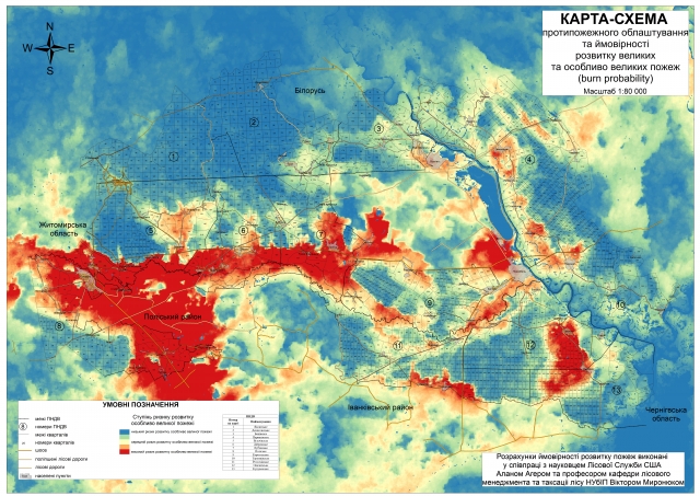
REEFMC has an expertise in advance mapping of surface and canopy fuels for large region (1135 thousand sq. km) using remote sensing data for classification of land cover, assessment of fuel load, fuel type and potential fire behaviour. Using simulation modelling (Flam Map, FConstMTT) to assess landscape scale wildfire exposure that allows quantifying different fuel treatment scenarios and improving fire management programs. Use of machine learning algorithms for predicting post-wildfire rehabilitation. Long –term mapping of ignition history for large region (Chernobyl Exclusion Zone, Polissia of Ukraine) based on MODIS (MOD/MYD14) daily data with delineation of fire perimeters. Developing of wildfire danger forecasting system for the Chernobyl Exclusion Zone. Fire breaks management scenarios. Computerize decision support system for prevention and suppression of fires in large regions with use of web-technologies.
Map of the burn probability on Chernobyl Exclusion Zone
Fire experiment in the scotch pine forests of the Central Polissia of Ukraine


