![]()


![]()


Assessing of forest fire severity in Luhansk region after fires 2020
A team of scientists from NBIP of Ukraine conducted research field work in the forests of Luhansk region, which were affected by fires in 2020. The purpose of the field-work was to inspect the burned areas of 2020, to collect materials about the fires and fire severity. The research activity are mostly located in the basins of the Siversky Donets and Aidar rivers (Kreminsky and Stanychno-Lugansky districts).

Two large forest fires occurred in the Luhansk oblast in 2020. Our stratification approach aimed to sample different types of land cover (forested and temporally unforested areas, non-forest lands), and potentially characterize the different effects of fire on vegetation.

Data on thermal anomalies for the territory were interactively analyzed using web-interface https://worldview.earthdata.nasa.gov/. Based on this, two large fires were identified that occurred within the research territory in 2020. The start date of the first fire (July 6, 2020) as well as the end date of the fires, that occurred at the end of September and at the beginning of October (October 9, 2020) were used to determine a time interval to select satellite images and analyze changes in spectral characteristics of land cover.
The forest inventory enterprise (PA Ukrderzhlisproject) database was used to assess the accuracy of the map of burned areas and further apply it in developing forest renewal strategy. Information on forested and unforested areas affected by fires was extracted from the database, then used to create an effective field sampling design. Thus, we focused on stratification approach that depicts the smallest number of homogeneous strata and could be used to prepare unified recommendation on forest renewal strategy.
The adopted scheme implies an unified forest recovery strategy within the appropriate level of fire intensity and soil burn severity class. Its quality was assessed statistically using a stratified sampling design which relies on both land cover classes and three levels of fire burn severity. The field sampling was designed so that it proportionally (to the area of a strata) reflects different types of land cover and the fire burn severity (Olofsson et al., 2014). At least three samples were taken in the strata (land category – burn severity), while their maximum number reached 14–18 for each stratum. In total, 73 test plots were laid out including seven control plots outside the burned areas.
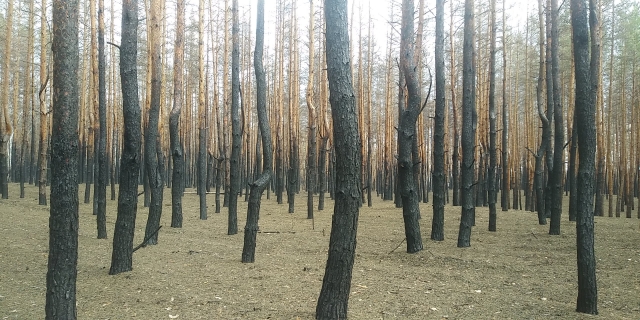
During field research, the actual level of fire burn severity was assessed at each sample site using determined on site the composite burn index (CBI) (Key & Benson, 2006) and its modified version, the GeoCBI index (De Santis & Chuvieco, 2009). Both indices are a comprehensive scoring of the fire burn severity expressed as the total value of disturbance level of various layers of vegetation: living aboveground soil, shrubs, stands. The GeoCBI additionally takes into account the fraction of cover (FCOV) of each strata, therefore is more efficient in terms of remote sensing-based estimation of the fire burn sevrity (Saulino et al., 2020). In addition, soil samples were taken from each site to determine the soil burn severity according to the BAER method (Parsons et al., 2010). The state of the territory was recorded using a series of images taken using the technique of creating 360-degrees panoramic photography of virtual reality VR360 (Myroniuk et al., 2020; See & Cheok, 2015).
Characteristic of fire burn severity and soil burn severity levels - Appendix 1.
According to the results of field surveys, the indices of pine plantation damage in each test plot were determined. Detailed information on each site is presented in Appendix 2.
Oleksandr Soshenskyi, Vasyl Gumeniuk