13 квітня 2020 року
Kyiv
Press Release
by the Regional Eastern Europe Fire Monitoring Center (REEFMC)
Regarding the Wildfires in and near the Chernobyl Exclusion Zone (CEZ) – 3-13 April 2020
Last Update: 13 April 2020
Prepared by Sergiy Zibtsev and Victor Myroniuk
Published on the websites of
Wildfire Situation in the Western Part of the CEZ near Narodychi City – 29 March to 12 April 2020
According to satellite remote sensing data, the first large fire in the Western part of the Chernobyl Exclusion Zone (CEZ) began on 29 March in the floodplain of Uzh river and burned territories mainly outside the CEZ. A small fire of the fire crossed the boundaries of the western part of CEZ and was stopped. The total area of the fire on 29 March 2020 was 736 hectares (ha) (Fig. 1). The fire mainly burned on grasslands.
Fig. 1. The first fire near the western border of the Exclusion Zone, which took place on 29 March 2020 in the floodplain of Uzh and crossed the border of the CEZ and was stopped. Area burnt:736 ha.
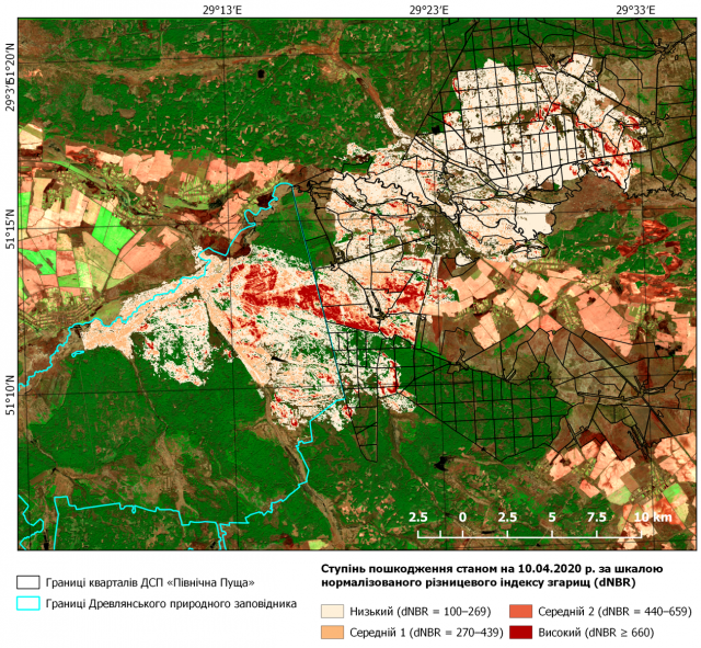
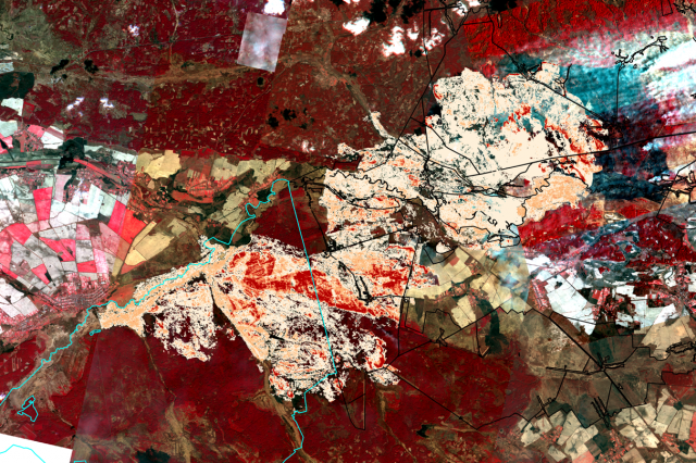
During the period 3 to 10 April 2020, a second large fire occurred, which started at the boundary of the floodplain of Uzh River and Narodichi City and spread towards Northeast along the territory of the Drevlyansky Nature Reserve and subsequently to the CEZ (Fig. 2). As of 10 April a fire from the Northern part burned in the Forest Management Units 183-186, 188, 189 and partially 205 of the Denysovetsky Districts Forestry of the North Puscha Forestry State Enterprise (Fig. 3).
Fig. 2. Between 3 and 10 April 2020 the wildfires burning in the vicinity of the settlements of Narodichi-Polissye, passed the territory of the Drevlyansky Nature Reserve and later entered the CEZ. The total area of the fire on 3-10 April was 19 200 hectares, including 6 000 ha in Drevlyanskiy Nature Reserve and 11 500 ha in the CEZ.
Between 3 and 10 April 2020 the fire merged with the burned area of the fire on 29 March 2020 (Fig. 1), resulting in a total area burned of 19 936 ha 10 April 2020 near Narodichi City and inside the Western part of the CEZ.
During 5 to 10 April 2020 the wildfire on the territory of the Denysovets Forestry of the Northern Puscah Forestry (Chernobyl Forest) reached the fire same area that was burned five years ago between 1 and 10 August 2015. This area was now completely burned for the second time. Since the forest stands had been largely destroyed by the fire of August 2015 the rate and intensity of this year’s fire was reduced. This allowed the firefighting forces to control the fire on 10 April 2020 at the same northern boundary as in 2015 (Fig. 4). However, on 12 April 2020 the fires flared-up again and spread towards North in the direction to Belarus (Fig. 5).

Fig. 3. Burnt areas and burning intensity (Difference Normalized Burn Ratio [dNBR]) during 5-10 April 2020 on the Kotovske and Denisovetske Forest Ranger Districts of Chernobyl Forestry Enterprise “Pivnichna Puscha”
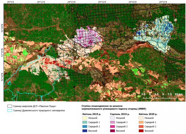
Fig. 4. Three areas burnt by fires in the CEZ and their intensity during 2015 and 2020: 1) 26-30 April 2015 (near Lubyanka village, 10 000 ha, top left, blue); 2) 1 to 10 August 2015 (Denysovetske ranger district, 5 000 ha, upper left), velvet; 3) 3 to 10 April 2020, 19 200 ha, red). The total area burnt by fires in 2015 and 2020 is 34 200 ha (not including the 10-km fire that began on 8 April 2020).
In summary, three large fires occurred in the CEZ in 2015 and 2020 (Fig. 4):
1) 26-30 April 2015 (near the village of Lubyanka, 10 000 ha, top left on the map)
2) 1-10 August 2015 (Denisovetsky Forestry, 5 000 ha, top left on the map)
3) 3-10 April 2020 (19 200 ha)
The total area burnt by fires in 2015 and 2020 is 34 200 ha
а)
b)
Fig. 5. Development of the fire in the western part of the CEZ as of 11 April 2020 (a) – burning continues at the Northern edge of the fire under the Western wind direction; and 12 April 2020 (b) – under the Southwestern wind the fire intensified and moved in the direction of the Belarusian border. Imageries: PlanetScope; acquisition dates: 11 April (a) and 12 April 2020 (b).
The fire in the 10-km zone, which began on 8 April 2020 currently continues to burn. The spread of the fire is being monitored and will be announced in the near future. As of 12 April 2020, the fire in its Northern part continues to develop (Fig. 6).

Fig. 6. Burning wildfire in 10-km zone of the CEZ as of 12 April 2020
End of press release of 13 April 2020
Information on Chernobyl Wildfires – 10 April 2020
During 6-9 of April the area affected by wildfires in the Western part of the CEZ increased accordingly to preliminary assessment to approximately 4 000 ha, and total burnt area near Narodychy Polesskii reached 12 000 ha (the area will be additional confirmed) (Fig.1).
Fig.1. Fire that is burning near Narodychy-Polesskii cities in the Western part of the Chernobyl Exclusion Zone (CEZ). By 10 April 2020 total area reached up to 12 000 ha. Image: PlanetScope, acquisition date and time 2020-04-08 T09:08:30
Another large forest fire started in the core zone of CEZ – near the “Red Forest” (the forest most contaminated and damaged by radiation stemming from the failure of Block No. 4 of the Chernobyl Nuclear Power Plant in 1986 (see figures below).
Fig.2. Large forest fire occurred 8-th of April 2020 in close vicinity of Red Forest in 10-km zone of the Chernobyl Exclusion Zone. Smoke is moving toward Belorussia. Preliminary assessment shows burned area at least 2000 ha. Image: PlanetScope, acquisition date and time 2020-04-09 T06:21:33
The State Scientific and Technical Center for Nuclear and Radiation Safety (SSTC NRS) of Ukraine provides forecasts of the movement of air masses potentially contaminated by fires burning in the CEZ (Fig.3.).
Fig.3. Large SSTC NRS model of smoke spread from CEZ on 10 and 11 April 2020. Please visit the English version of the SSTC NRS website: https://sstc.ua/news/prognoz-peremishennya-potencijno-zabrudnenogo-atmosfernogo-povitrya-zumovlenogo-pozhezhami-v-chzv-na-10-11-kvitnya
A few photos from the ground visualize the generation and transport of fire smoke from the CEZ:
Photos: Denis Vishnevskii
Below – Earlier Press Release of REEFMC of 5 April 2020
Please note that the threat of radiation in the early days of the fire episode was lower than on 10 April 2020
Since 2007, REEFMC has been actively working with agencies of Ukraine and international partners (the Global Fire Monitoring Center [GFMC] by sponsorship of the Council of Europe’s Major Hazard Agreement and the Organization for Security and Cooperation in Europe [OSCE], and the US Forest Service) over increasing preparedness and safety and capacity of fire management in terrains contaminated by radionuclides in the Chornobyl Exclusion Zone (CEZ) [1]. In April and August 2015 two major wildfires inside the CEZ burned around 15.000 ha. The emissions of these fires resulted in aerial transport of radionuclides beyond the CEZ borders [2].
Based on the dedicated activities of REEFMC and partners, including the support by US Forest Service, a number of recommendations and guidelines have been developed between 2016 and 2018, aimed at improvement of individual protection of firefighters, strategies and tactics of fire management in contaminated terrain. Among other, a burn probability map of CEZ and vicinity was developed that can be used by firefighting services to prevent fires and provide a fast fire response (the map is available on the website of REEFMC) (Fig. 1) [3, 4, 5, 6].
Fig. 1.1 Distribution of the burn probability index across the CEZ and firefighting infrastructure. REEFMC: S. Zibtsev, V. Myroniuk, V. Bogomolov, O. Soshenskiy (2020).
Area of the fire on 3-5 of April 2020 has high burn probability and high radionuclide contamination (Fig. 2) between Narodychi city, the Drevlianskiy Nature Reserve and the CEZ. The area affected by fire has no maintained road system and is hardly accessible for firefighting brigades.
The fire started at the western Chornobyl radioactive contamination path, bordering with Narodychi city and the Uzh River floodplains (Fig. 2) at around 17:00 / 18:00 h on 3 April 2020, probably because of intentional or unintentional grasslands / pasture burning, under west direction wind with speed 3-5 m/s.
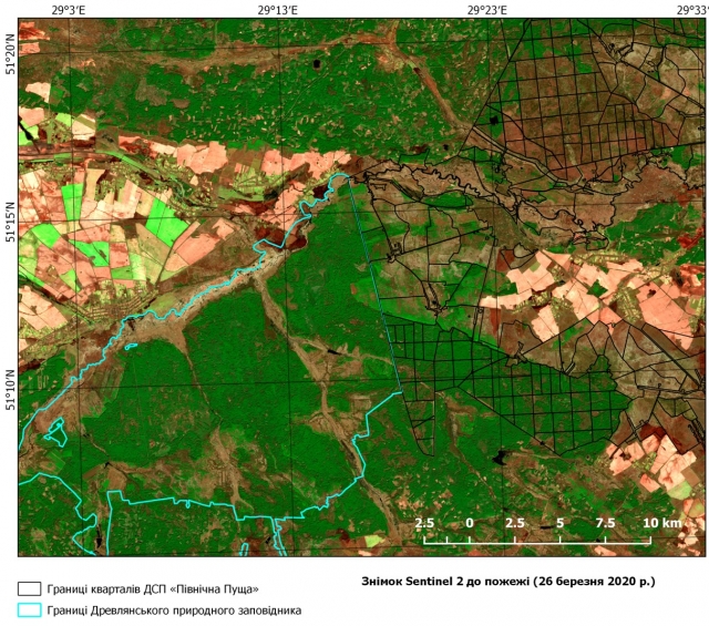
Fig.2.1 Pre-fire situation: blue line – border of Drevlianskii Reserve; black lines – forests of CEZ, villages and farmlands. Source: Sentinel-2, 26 March 2020.
In the morning on 4 April and during 5 April the wind had speeded up to 5-8 m/s, which contributed to fast spread of the fire (Fig. 3).
Fig. 3.1 Composite Planet satellite image of the fire development on the territory of the western part of the CEZ, 3-5 April 2020. Image: PlanetScope.
The fire moved across the territory of Drevliansky Nature Reserve towards villages Kotovske and Ragivka on northeast mainly along the left-bank part of the Uzh River floodplain with access to fallows covered by natural renewal of pine and birch, which increased the intensity of burning. The fire moved along the Zvizdal river as well and continued to move towards active farmlands located at the western part of Ragivka village, where it was extinguished or stopped (Fig. 4 and 5). Fig. 4 illustrates a new fire (field burn, which moved to the CEZ), that was ignited by residents of Ragivka on 5 April, despite the fact that a large fire occurred nearby, which was suppressed by fire with.
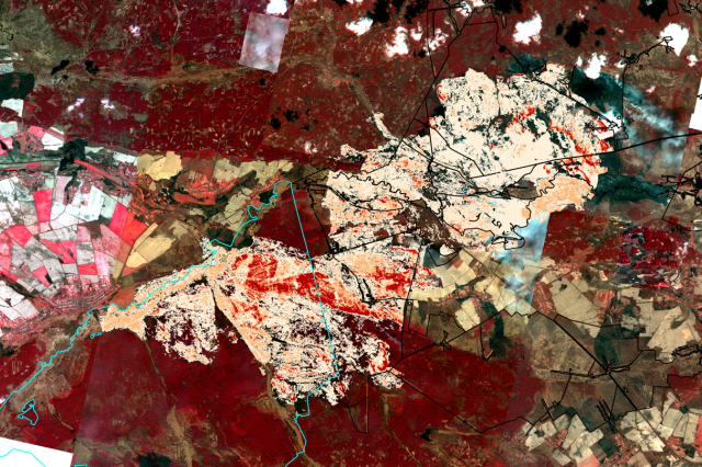
Fig. 4.1 Burning intensity according to dNBR index
Fig. 5.1 Territory affected by fire on 3-5 April 2020 as of 5 April. According to satellite data the overall area burned is 7811 ha, including 2398 ha of the CEZ and 4914 ha of Drevlianskii Reserve.
Total expected doses of firefighters during one hour of suppression are in range from 0,2 to 2,27 microsievert (Fig. 6). As most part of fire burned grasslands with relative low temperature migration of radionuclides with smoke has local scale.
Fig. 6.1 Total expected doses (internal + external) of fire fighters during one hour of suppression on fire line of fire 3-5 April 2020.
Fig.7.1 Aerial view of the fires burning through an intermix of grasslands and forested lands. Photo: State Emergency Service of Ukraine.
Consequences on health and security of firefighters and the public
In the early stage the main fires burned on grasslands, with a low- to medium intensity. According to earlier research the aerial transport and deposition of radionuclides is limited to the immediate vicinity of the fires. Thus, in that stage they represented a threat to firefighters and not to the populated areas in the downwind direction. In the following days the fires moved to forests damaged by the failure of the Reactor Block 4 of the Chernobyl Nuclear Power Plant in 1986.
References:
1. International efforts aimed in increasing capacity of prevention and safe management of fires in the Chernobyl Exclusion Zone https://nubip.edu.ua/en/node/9087/7.
2. Evangeliou N., Zibtsev S., Myroniuk V., Zhurba M. et al. Resuspension and atmospheric transport of radionuclides due to wildfires near the Chernobyl Nuclear Power Plant in 2015: An impact assessment. Scientific Reports. 2016. Vol. 6. Article number: 26062. Doi: 10.1038/srep26062. URL: http://rdcu.be/i1GL.
3. Ager A.A., Lasko R., Myroniuk M., Zibtsev S., Day M.A., Usenia V., Bogomolov V., Kovalets I., Evers C.R. The wildfire problem in areas contaminated by the Chernobyl disaster. Science of the Total Environment 696 (2019) 133954.
https://doi.org/10.1016/j.scitotenv.2019.133954. URL: https://nubip.edu.ua/sites/default/files/u184/ager_final_ste_1-s2.0-s0048969719339245-main.pdf
4. Pocket Guideline for forest firefighters of the Chernobyl Exclusion Zone. Regional Eastern Europe Fire Monitoring Center, US Forest Service, 2018. 150 p. https://nubip.edu.ua/sites/default/files/u184/irpg_ukr_chornobyl_forest_firefighters_2018.pdf
5. Burn probability map of the CEZ: https://nubip.edu.ua/sites/default/files/u184/karta_burn_probaility_vb_14-01-2020_1.jpg
6. Global Fire Monitoring Center (GFMC) website on fire management on terrain contaminated by radioactivity and unexploded ordnance: https://gfmc.online/globalnetworks/seeurope/SEEurope_1_radio.html
7. Planet Team (2017). Planet Application Program Interface: In Space for Life on Earth. San Francisco, CA. https://api.planet.com

