
Неймовірна можливість [вивчення англійської мови безкоштовно!] Реєстрацію відкрито!
 За фінансової підтримки британського благодійного фонду Маріупольський державний університет отримав права на однойменну електронну платформу для вивчення англійської мови від компанії Reallyenglish.com Limited, яка більше 20 років допомагає навчати іноземній фахівців корпорацій і закладів освіти. На теренах України платформа працюватиме під назвою English4Ukraine.
У межах співпраці протягом року МДУ надаватиме безкоштовний доступ до навчальних курсів освітянам.
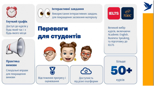
Вивчати англійську мову з English4Ukraine зручно як на мобільних пристроях, так і та персональних комп’ютерах. Платформа містить 30 навчальних курсів для різних рівнів володіння мовою (від А1 до С2), які охоплюють загальну, ділову, академічну, спеціалізовану (ESP) англійську, підготовку до тестувань IELTS, TOEIC і TOEFL. За допомогою уроків можна покращити навички говоріння, аудіювання та письма, розширити словниковий запас.
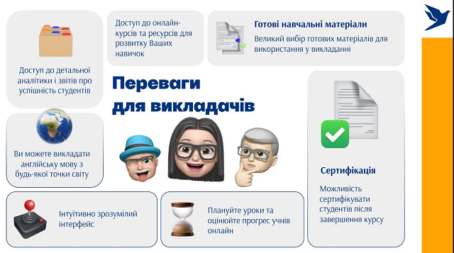
Про переваги для студентів та викладачів:
Що для цього необхідно зробити??
— Ознайомитись з інформацією про курси, обрати найбільш цікавий(ві)* для Вас
*Один користувач може обрати до 2-х курсів на платформі та проходити навчання паралельно.
— Заповнити гугл-форму: https://forms.gle/DjWcPyh76fB6dP1Z6
— Очікувати доступ від координатора.
Дедлайн: 13.09.2024 р.
Користувачі мають змогу пройти курси, на які їх було підписано протягом 120 днів з дати реєстрації на курс. У разі вчасного та успішного завершення курсу видається сертифікат про його проходження.
Шановні освітяни, просимо відповідально поставитись до даної пропозиції, протягом вашого навчання буде здійснюватись моніторинг результатів успішності!
Бажаємо успіхів!